


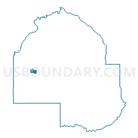
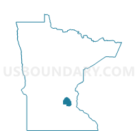
Maple Plain P-1, Hennepin County, Minnesota
About
Outline

Summary
| Unique Area Identifier | 602479 |
| Name | Maple Plain P-1 |
| County | Hennepin County |
| State | Minnesota |
| Area (square miles) | 1.12 |
| Land Area (square miles) | 1.11 |
| Water Area (square miles) | 0.00 |
| % of Land Area | 99.58 |
| % of Water Area | 0.42 |
| Latitude of the Internal Point | 45.01044190 |
| Longtitude of the Internal Point | -93.66069830 |
Maps

Graphs
Select a template below for downloading or customizing gragh for Maple Plain P-1, Hennepin County, Minnesota


Neighbors
Neighoring Voting District (by Name) Neighboring Voting District on the Map
Top 10 Neighboring County Subdivision (by Population) Neighboring County Subdivision on the Map
- Medina city, Hennepin County, MN (4,892)
- Independence city, Hennepin County, MN (3,504)
- Maple Plain city, Hennepin County, MN (1,768)